
Nuptse I地形图
点击地图以显示海拔。
Nuptse I
Nuptse or Nubtse (Sherpa: ནུབ་རྩེ། नुबचे, Wylie: Nub rtse, Chinese: 努子峰) is a mountain in the Khumbu region of the Mahalangur Himal, in the Nepalese Himalayas. It lies 2 km (1.2 mi) WSW of Mount Everest. The main peak, Nuptse I at an elevation of 7,861 m (25,791 ft), was first climbed on May 16, 1961, by Dennis Davis and Sherpa Tashi. After a hiatus of almost 20 years, Nuptse again became the objective of mountaineers, with important routes being put up on its west, south, and north faces.
关于这张地图
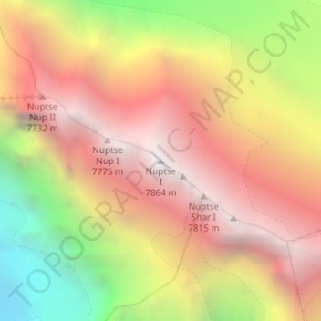
名称:Nuptse I地形图、海拔、地势。
地点:Nuptse I, Khumbupasanglahmu, Solukhumbu, Koshi Province, Nepal (27.96732 86.88691 27.96742 86.88701)
平均海拔:6,833 米
最低海拔:5,456 米
最高海拔:7,832 米
其他地形图
点击地图以查看其地形、其海拔和其地势。