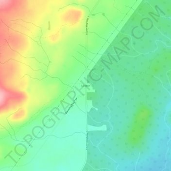
地理定位

London地形图

点击地图以显示海拔

关于这张地图

名称London地形图、海拔、地势。

地点London, Silver Creek Township, Lake County, Minnesota, United States (47.18270 -91.58962 47.22270 -91.54962)

平均海拔:406 米

最低海拔:360 米

最高海拔:495 米

其他地形图

点击地图以查看其地形、其海拔和其地势

Lake No. 2

United States > Minnesota > Lake County

平均海拔:428 米

Lake No. 1

United States > Minnesota > Lake County

平均海拔:453 米

Silver Bay

United States > Minnesota > Lake County

平均海拔:247 米

Silver Bay

United States > Minnesota > Lake County

平均海拔:247 米

Two Harbors

United States > Minnesota > Lake County

平均海拔:221 米

Hum Lake

United States > Minnesota > Lake County

平均海拔:468 米

Garden Lake

United States > Minnesota > Lake County

平均海拔:426 米

Gull Lake

United States > Minnesota > Lake County

平均海拔:467 米

Two Harbors

United States > Minnesota > Lake County

平均海拔:221 米

Beaver Bay

United States > Minnesota > Lake County

平均海拔:212 米

Bow Lake

United States > Minnesota > Lake County

平均海拔:477 米

Griddle Lake

United States > Minnesota > Lake County

平均海拔:444 米