
Samaria地形图
点击地图以显示海拔。
关于这张地图
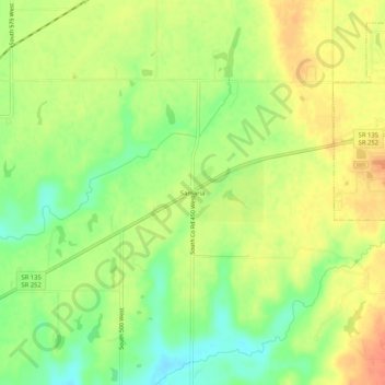
名称:Samaria地形图、海拔、地势。
地点:Samaria, Johnson County, Indiana, 46181, United States (39.38394 -86.20638 39.42394 -86.16638)
平均海拔:243 米
最低海拔:217 米
最高海拔:266 米
其他地形图
点击地图以查看其地形、其海拔和其地势。
Greenwood
United States > Indiana > Johnson County
Greenwood's mean elevation is 813 feet (248 m) above sea level. The city's topography is flat to gently rolling.
平均海拔:245 米
Greenwood
United States > Indiana > Johnson County
Greenwood's mean elevation is 813 feet (248 m) above sea level. The city's topography is flat to gently rolling.
平均海拔:245 米