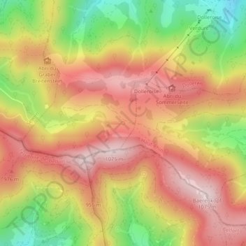
点击地图以显示海拔。
名称:Source de la Doller地形图、海拔、地势。
地点:Source de la Doller, Chemin du Hirtzelach, Sewen, Thann-Guebwiller, Haut-Rhin, Grand Est, France métropolitaine, 68290, France (47.78063 6.90839 47.78073 6.90849)
平均海拔:876 米
最低海拔:625 米
最高海拔:1,059 米
点击地图以查看其地形、其海拔和其地势。
France > Grand Est > Haut-Rhin > Sewen
平均海拔:834 米
France > Grand Est > Haut-Rhin > Sewen > Birlen
平均海拔:691 米