
Tepoztlán地形图
点击地图以显示海拔。
关于这张地图
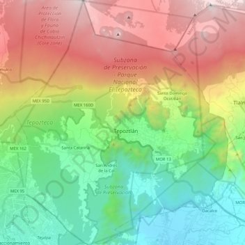
名称:Tepoztlán地形图、海拔、地势。
地点:Tepoztlán, Morelos, Mexico (18.89609 -99.19335 19.08930 -99.01456)
平均海拔:2,098 米
最低海拔:1,215 米
最高海拔:3,469 米
其他地形图
点击地图以查看其地形、其海拔和其地势。
Cuernavaca
Mexico > Morelos > Cuernavaca
The city is located in a tropical region, but its temperature is fairly constant at 21–26 °C (70–79 °F). It is located on the southern slope of the Sierra de Chichinautzin mountains. In the morning, warm air flows up the mountains from the valley below and in the late afternoon, cooler air flows down…
平均海拔:1,822 米