
Austin地形图
点击地图以显示海拔。
Austin
Austin is an unincorporated small town in, and former county seat of, Lander County, Nevada, United States. In 2020, the census-designated place of Austin had a population of 167. It is located on the western slopes of the Toiyabe Range at an elevation of 6,575 feet (2,004 m). U.S. Route 50 passes through the town.
关于这张地图
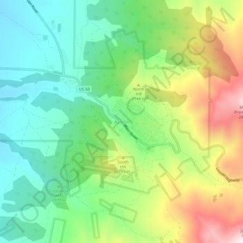
名称:Austin地形图、海拔、地势。
地点:Austin, Lander County, Nevada, United States (39.47326 -117.08954 39.51326 -117.04954)
平均海拔:2,076 米
最低海拔:1,841 米
最高海拔:2,464 米
其他地形图
点击地图以查看其地形、其海拔和其地势。
Battle Mountain
United States > Nevada > Lander County
Battle Mountain's climate is cool semi-arid (Köppen climate classification BSk), receiving just enough precipitation to avoid arid classification. Due to aridity and high elevation, the area commonly experiences large diurnal temperature variation, particularly in summer, when it averages almost 45 °F or 25…
平均海拔:1,376 米