
Medan地形图
点击地图以显示海拔。
Medan
Medan's elevation varies between 2.5 and 37.5 m (8 ft 2 in and 123 ft 0 in) above sea level, with the Barisan Mountains to the south, and volcanoes such as Sibayak Mountain and Sinabung Mountain 50 to 70 km (31 to 43 mi) from the city.
关于这张地图
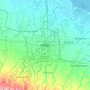
名称:Medan地形图、海拔、地势。
地点:Medan, City of Medan, North Sumatra, Sumatra, Indonesia (3.42967 98.51383 3.74967 98.83383)
平均海拔:32 米
最低海拔:-2 米
最高海拔:187 米
其他地形图
点击地图以查看其地形、其海拔和其地势。