
Mawadin地形图
点击地图以显示海拔。
关于这张地图
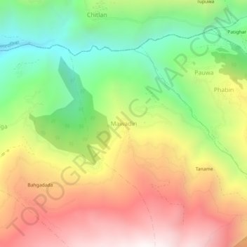
名称:Mawadin地形图、海拔、地势。
地点:Mawadin, Madi, Sankhuwasabha, Koshi Province, 56900, Nepal (27.26726 87.39615 27.30726 87.43615)
平均海拔:1,634 米
最低海拔:967 米
最高海拔:2,366 米
其他地形图
点击地图以查看其地形、其海拔和其地势。
Arun River
Nepal > Koshi Province > Sankhuwasabha > Num
The Tibetan name Bum-chu may refer to a religious ceremony attempting to divine prospects for the coming year from the level of water in a pot or well, chu is the Tibetan word for water. The river originates near Gutso in Nyalam County of Tibet. Around 17 kilometres (11 mi) downstream, the Men-chu joins it.…
平均海拔:1,153 米