Olivet Hill地形图
点击地图以显示海拔。
关于这张地图
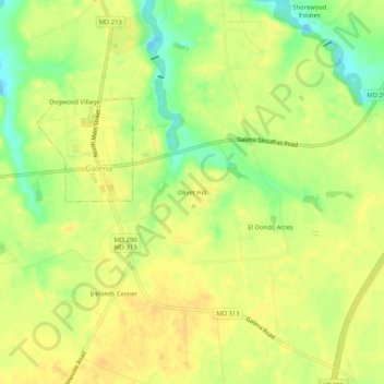
名称:Olivet Hill地形图、海拔、地势。
地点:Olivet Hill, Kent County, Maryland, 21650, United States (39.31817 -75.88605 39.35817 -75.84605)
平均海拔:18 米
最低海拔:-4 米
最高海拔:26 米
其他地形图
点击地图以查看其地形、其海拔和其地势。

点击地图以显示海拔。
名称:Olivet Hill地形图、海拔、地势。
地点:Olivet Hill, Kent County, Maryland, 21650, United States (39.31817 -75.88605 39.35817 -75.84605)
平均海拔:18 米
最低海拔:-4 米
最高海拔:26 米
点击地图以查看其地形、其海拔和其地势。