
Cabauw地形图
点击地图以显示海拔。
关于这张地图
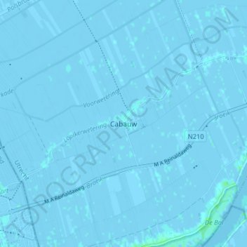
名称:Cabauw地形图、海拔、地势。
地点:Cabauw, Lopik, Utrecht, Netherlands, 3411 ED, Netherlands (51.94426 4.87778 51.98426 4.91778)
平均海拔:-1 米
最低海拔:-5 米
最高海拔:5 米
其他地形图
点击地图以查看其地形、其海拔和其地势。
Amersfoort
The construction of the tower and the church was started in 1444. The church was destroyed by an explosion in 1787, but the tower survived, and the layout of the church still can be discerned today through the use of different types of stone in the pavement of the open space that was created. It is now the…
平均海拔:7 米
Woudenberg
Netherlands > Utrecht > Woudenberg
Dutch Topographic map of the municipality of Woudenberg, 2013.
平均海拔:13 米
Wijk bij Duurstede
Dutch Topographic map of the municipality of Wijk bij Duurstede, 2013.
平均海拔:7 米
Wijk bij Duurstede
Netherlands > Utrecht > Wijk bij Duurstede
Dutch Topographic map of the municipality of Wijk bij Duurstede, 2013.
平均海拔:5 米
Amersfoort
The construction of the tower and the church was started in 1444. The church was destroyed by an explosion in 1787, but the tower survived, and the layout of the church still can be discerned today through the use of different types of stone in the pavement of the open space that was created. It is now the…
平均海拔:7 米
Rhenen
Rhenen (Dutch pronunciation: [ˈreːnə(n)] ) is a municipality and a city in the central Netherlands. The municipality also includes the villages of Achterberg, Remmerden [nl], Elst and . The town lies at a geographically interesting location, namely on the southernmost part of the chain of hills known as the…
平均海拔:13 米
Amersfoort
The construction of the tower and the church was started in 1444. The church was destroyed by an explosion in 1787, but the tower survived, and the layout of the church still can be discerned today through the use of different types of stone in the pavement of the open space that was created. It is now the…
平均海拔:6 米
Montfoort
Netherlands > Utrecht > Montfoort
Dutch topographic map of the municipality of Montfoort, June 2015
平均海拔:0 米
Rhenen
Netherlands > Utrecht > Rhenen
Rhenen (Dutch pronunciation: [ˈreːnə(n)] ) is a municipality and a city in the central Netherlands. The municipality also includes the villages of Achterberg, Remmerden, Elst and Laareind. The town lies at a geographically interesting location, namely on the southernmost part of the chain of hills known as…
平均海拔:14 米