
Mandali地形图
点击地图以显示海拔。
关于这张地图
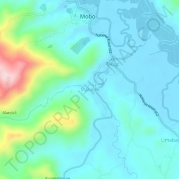
名称:Mandali地形图、海拔、地势。
地点:Mandali, Masbate, Bicol Region, 5401, Philippines (12.30025 123.63853 12.34025 123.67853)
平均海拔:66 米
最低海拔:-5 米
最高海拔:350 米
其他地形图
点击地图以查看其地形、其海拔和其地势。
Jintotolo Island
Philippines > Masbate > Jintotolo
Its elevation was recorded at around 120 feet (37 m) in 1919. A lighthouse with a tower at 51 feet (16 m) in height exists on Jintotolo island.
平均海拔:6 米