
Faridkot地形图
点击地图以显示海拔。
关于这张地图
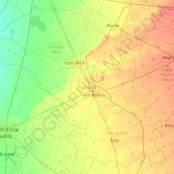
名称:Faridkot地形图、海拔、地势。
地点:Faridkot, Punjab, India (30.36627 74.46883 30.83643 75.05409)
平均海拔:206 米
最低海拔:191 米
最高海拔:222 米
其他地形图
点击地图以查看其地形、其海拔和其地势。
Rupnagar
India > Punjab > Rupnagar Tahsil
Rupnagar is located at 30°58′N 76°32′E / 30.97°N 76.53°E / 30.97; 76.53. It has an average elevation of 260 metres (850 ft). The town lies on the bank of Satluj River and the Shivalik hill range spreads along the opposite bank of the river.
平均海拔:281 米
Ludhiana
India > Punjab > Ludhiana (West) Tahsil
Ludhiana is located at 30°54′N 75°51′E / 30.9°N 75.85°E / 30.9; 75.85. It has an average elevation of 244 metres (801 ft). Ludhiana City, to its residents, consists of the Old City and the New City. The new city primarily consists of the Civil Lines area which was historically known as the…
平均海拔:247 米
Rajpura
India > Punjab > Rajpura Tahsil
Rajpura is located at 30°29′N 76°36′E / 30.48°N 76.6°E / 30.48; 76.6. It has an average elevation of 259 metres (849 feet). Rajpura is situated nearly 38 km south west of Chandigarh, the capital city of Punjab. Besides being an important industrial town of Punjab, it also has historical importance.
平均海拔:270 米
Jagraon
India > Punjab > Jagraon Tahsil
Jagraon is located at 30°47′N 75°29′E / 30.78°N 75.48°E / 30.78; 75.48. It has an average elevation of 234 metres (768 ft).
平均海拔:234 米
Makhu
India > Punjab > Zira Tahsil
Makhu has an average elevation of 201 metres (659 feet). This town is located near the edge of Harike Sanctuary. It is 5 km away from the confluence of Satluj and Beas rivers.
平均海拔:210 米
Amritsar
India > Punjab > Amritsar I Tahsil
Amritsar is located at 31°38′N 74°52′E / 31.63°N 74.87°E / 31.63; 74.87 with an average elevation of 234 metres (768 ft) in the Majha region of the state of Punjab in North India and lies about 15 miles (24 km) east of the border with Pakistan. Administrative towns includes Ajnala, Attari,…
平均海拔:231 米
Rupnagar
India > Punjab > Rupnagar Tahsil
Rupnagar is located at 30°58′N 76°32′E / 30.97°N 76.53°E / 30.97; 76.53. It has an average elevation of 260 metres (850 ft). The town lies on the bank of Satluj River and the Shivalik hill range spreads along the opposite bank of the river.
平均海拔:281 米
Nabha
India > Punjab > Nabha Tahsil
Nabha is located at 30°22′N 76°09′E / 30.37°N 76.15°E / 30.37; 76.15. It has an average elevation of 246 metres (807 feet).
平均海拔:251 米
Budhlada
India > Punjab > Budhlada Tahsil
Budhlada is located at 29°56′N 75°34′E / 29.93°N 75.57°E / 29.93; 75.57 and has an average elevation of 211 metres (692 ft). The border of Haryana state is 25 kilometres (16 mi) away from the city.
平均海拔:221 米
Ludhiana
India > Punjab > Ludhiana (West) Tahsil
Ludhiana is located at 30°54′N 75°51′E / 30.9°N 75.85°E / 30.9; 75.85. It has an average elevation of 244 metres (801 ft). Ludhiana City, to its residents, consists of the Old City and the New City. The new city primarily consists of the Civil Lines area which was historically known as the…
平均海拔:247 米
Amritsar
India > Punjab > Amritsar I Tahsil
Amritsar is located at 31°38′N 74°52′E / 31.63°N 74.87°E / 31.63; 74.87 with an average elevation of 234 metres (768 ft) in the Majha region of the state of Punjab in North India and lies about 15 miles (24 km) east of the border with Pakistan. Administrative towns includes Ajnala, Attari,…
平均海拔:231 米
Amritsar
India > Punjab > Amritsar I Tahsil
Amritsar is located at 31°38′N 74°52′E / 31.63°N 74.87°E / 31.63; 74.87 with an average elevation of 234 metres (768 ft). Amritsar is located in the Majha region of the state of Punjab in North India lies about 15 miles (25 km) east of the border with Pakistan. Administrative towns includes…
平均海拔:231 米