
Wantage Township地形图
点击地图以显示海拔。
关于这张地图
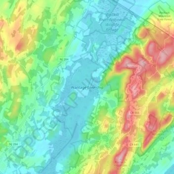
名称:Wantage Township地形图、海拔、地势。
平均海拔:191 米
最低海拔:113 米
最高海拔:361 米
其他地形图
点击地图以查看其地形、其海拔和其地势。
Vernon Township
United States > New Jersey > Sussex County
Elevation varies greatly due to the valleys, rolling hills, and mountains. The United States Geological Survey places Glenwood at 580 feet (180 m), McAfee at 435 feet (133 m), and Highland Lakes at 1,260 feet (380 m).
平均海拔:253 米
Stillwater Township
United States > New Jersey > Sussex County
Flanked to the west by Kittatinny Mountain, the Stillwater Township is located within the Ridge and Valley Physiographic Province, and the entire township is within the Kittatinny Valley a region of rolling hills and flat valley floors that is a section of the larger Great Appalachian Valley running 700 miles…
平均海拔:244 米
Newton
United States > New Jersey > Sussex County
Because of its location in the higher elevations of northwestern New Jersey's Appalachian mountains, Newton, as well as the rest of Sussex County, has a cooler humid continental climate or microthermal climate (Köppen climate classification Dfb) which indicates patterns of significant precipitation in all…
平均海拔:202 米
Stillwater Township
United States > New Jersey > Sussex County
Flanked to the west by Kittatinny Mountain, the Stillwater Township is located within the Ridge and Valley Physiographic Province, and the entire township is within the Kittatinny Valley a region of rolling hills and flat valley floors that is a section of the larger Great Appalachian Valley running 700 miles…
平均海拔:244 米
High Point State Park
United States > New Jersey > Sussex County > Montague Township
High Point State Park is a state park straddling the border of Wantage Township and Montague Township in Sussex County, within the Skylands Region of northwestern New Jersey, United States, near the border with New York State and Pennsylvania. The park covers 15,413 acres (62.37 km2). Part of the Kittatinny…
平均海拔:257 米
Stokes State Forest
United States > New Jersey > Sussex County > Sandyston Township
The pavilion at the top of the peak makes a great place to picnic. To make traveling to Sunrise more interesting, one can look for the New Jersey shaped rock. The mountain is the second highest point in New Jersey, being 1,653 feet (504 m) above sea level. Hikers are amazed with the view. There is a USGS…
平均海拔:260 米
Kittatinny Mountain
United States > New Jersey > Sussex County
Kittatinny Mountain (Lenape: Kitahtëne) is a long ridge traversing primarily across Sussex County in northwestern New Jersey, running in a northeast-southwest axis, a continuation across the Delaware Water Gap of Pennsylvania's Blue Mountain (also known as Kittatinny Ridge). It is the first major ridge in the…
平均海拔:266 米
Vernon Township
United States > New Jersey > Sussex County
Elevation varies greatly due to the valleys, rolling hills, and mountains. The United States Geological Survey places Glenwood at 580 feet (180 m), McAfee at 435 feet (133 m), and Highland Lakes at 1,260 feet (380 m).
平均海拔:253 米
High Point State Park
United States > New Jersey > Sussex County > Montague Township
High Point State Park is a state park straddling the border of Wantage Township and Montague Township in Sussex County, within the Skylands Region of northwestern New Jersey, United States, near the border with New York State and Pennsylvania. The park covers 15,413 acres (62.37 km2). Part of the Kittatinny…
平均海拔:255 米
Montague Township
United States > New Jersey > Sussex County
Montague Township is a township in Sussex County, in the U.S. state of New Jersey, in the New York City Metropolitan Area. As of the 2020 United States census, the township's population was 3,792, a decrease of 55 (−1.4%) from the 2010 census count of 3,847, which in turn reflected an increase of 435…
平均海拔:254 米
Stillwater Township
United States > New Jersey > Sussex County
Flanked to the west by Kittatinny Mountain, the Stillwater Township is located within the Ridge and Valley Physiographic Province, and the entire township is within the Kittatinny Valley a region of rolling hills and flat valley floors that is a section of the larger Great Appalachian Valley running 700 miles…
平均海拔:244 米
Newton
United States > New Jersey > Sussex County
Because of its location in the higher elevations of northwestern New Jersey's Appalachian mountains, Newton, as well as the rest of Sussex County, has a cooler humid continental climate or microthermal climate (Köppen climate classification Dfb) which indicates patterns of significant precipitation in all…
平均海拔:202 米
Montague Township
United States > New Jersey > Sussex County
Montague Township is a township in Sussex County, in the U.S. state of New Jersey, in the New York City Metropolitan Area. As of the 2020 United States census, the township's population was 3,792, a decrease of 55 (−1.4%) from the 2010 census count of 3,847, which in turn reflected an increase of 435…
平均海拔:254 米