Plettenberg Bay地形图
点击地图以显示海拔。
关于这张地图
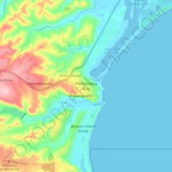
名称:Plettenberg Bay地形图、海拔、地势。
地点:Plettenberg Bay, George, Western Cape, 6600, South Africa (-34.09278 23.32944 -34.01278 23.40944)
平均海拔:47 米
最低海拔:-3 米
最高海拔:198 米
其他地形图
点击地图以查看其地形、其海拔和其地势。

点击地图以显示海拔。
名称:Plettenberg Bay地形图、海拔、地势。
地点:Plettenberg Bay, George, Western Cape, 6600, South Africa (-34.09278 23.32944 -34.01278 23.40944)
平均海拔:47 米
最低海拔:-3 米
最高海拔:198 米
点击地图以查看其地形、其海拔和其地势。