点击地图以显示海拔。
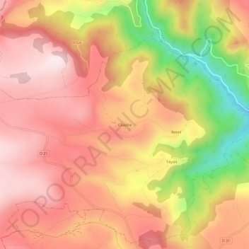
名称:Chastre地形图、海拔、地势。
地点:Chastre, Allanche, Saint-Flour, Cantal, Auvergne-Rhône-Alpes, France métropolitaine, 15160, France (45.22530 2.98346 45.26530 3.02346)
平均海拔:1,094 米
最低海拔:801 米
最高海拔:1,261 米
点击地图以查看其地形、其海拔和其地势。
France > Auvergne-Rhône-Alpes > Cantal > Allanche
平均海拔:1,067 米