
Texas Creek地形图
点击地图以显示海拔。
关于这张地图
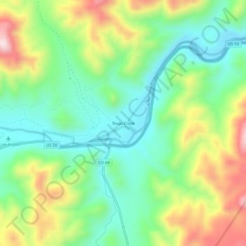
名称:Texas Creek地形图、海拔、地势。
平均海拔:2,039 米
最低海拔:1,863 米
最高海拔:2,349 米
其他地形图
点击地图以查看其地形、其海拔和其地势。
Cañon City
United States > Colorado > Fremont County
The city's nickname, "the Climate Capital of Colorado", derives from the combination of unique geography and 5,300-foot (1,600 m) elevation protecting the city from harsh weather conditions. The average daily high temperature in January is 14 °F (7.8 °C) warmer in Cañon City than in Grand Junction, even…
平均海拔:1,723 米
Cañon City
United States > Colorado > Fremont County
The city's nickname, "the Climate Capital of Colorado", derives from the combination of unique geography and 5,300-foot (1,600 m) elevation protecting the city from harsh weather conditions. The average daily high temperature in January is 14 °F (7.8 °C) warmer in Cañon City than in Grand Junction, even…
平均海拔:1,750 米
Cañon City
United States > Colorado > Fremont County
Cañon City is located in eastern Fremont County at 38°26′48″N 105°13′42″W / 38.44667°N 105.22833°W / 38.44667; -105.22833 (38.446800, -105.228305) at an altitude of 5,332 feet (1,625 m). It sits primarily on the north side of the Arkansas River, just east of where the river exits from…
平均海拔:1,723 米