
Granger地形图
点击地图以显示海拔。
关于这张地图
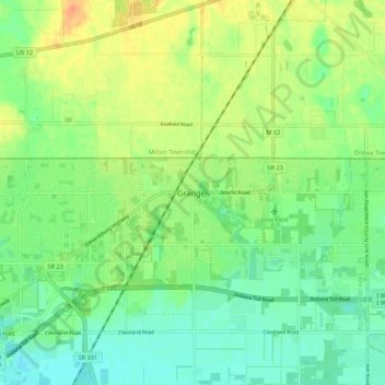
名称:Granger地形图、海拔、地势。
地点:Granger, Saint Joseph County, Indiana, 46530, United States (41.71338 -86.15084 41.79338 -86.07084)
平均海拔:244 米
最低海拔:228 米
最高海拔:266 米
其他地形图
点击地图以查看其地形、其海拔和其地势。
South Bend
United States > Indiana > Saint Joseph County
On September 29, 1929, South Bend completed its "track elevation program". This was a railroad infrastructure project which saw the removal of Grand Trunk Western Railroad tracks from Division Street, the removal of level crossings from Chapin to Miami streets, the creation of a modern freight layout, and the…
平均海拔:236 米