
Mahesana地形图
点击地图以显示海拔。
Mahesana
Mehsana has an average elevation of 375 feet (114 m) above sea level. By Ahmedabad-Palanpur Railway line, the town is divided in two: the east and western parts are known as Mehsana-1 and Mehsana-2 respectively.
关于这张地图
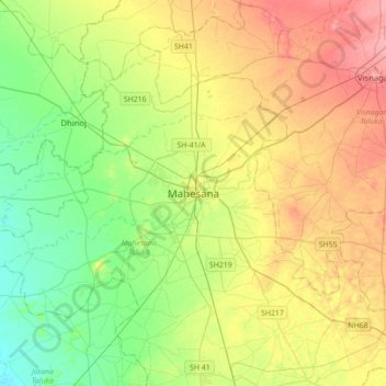
名称:Mahesana地形图、海拔、地势。
地点:Mahesana, Mahesana Taluka, Mahesana, Gujarat, 384001, India (23.44156 72.22680 23.76156 72.54680)
平均海拔:92 米
最低海拔:59 米
最高海拔:138 米