
Yonkers地形图
点击地图以显示海拔。
关于这张地图
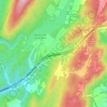
名称:Yonkers地形图、海拔、地势。
地点:Yonkers, Allegany County, Maryland, United States (39.67509 -78.66891 39.71509 -78.62891)
平均海拔:426 米
最低海拔:263 米
最高海拔:628 米
其他地形图
点击地图以查看其地形、其海拔和其地势。
Frostburg
United States > Maryland > Allegany County
Due to its average elevation of 2,000 feet (610 m) above sea level and location near the Allegheny Front, Frostburg has a colder, wetter climate than much of the rest of the state, and falls in USDA hardiness zone 6b. Under the Köppen climate classification, it has a humid continental climate (Dfb), with…
平均海拔:620 米