
Minnedosa地形图
点击地图以显示海拔。
关于这张地图
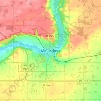
名称:Minnedosa地形图、海拔、地势。
地点:Minnedosa, Manitoba, R0J 1E0, Canada (50.20987 -99.87852 50.28987 -99.79852)
平均海拔:552 米
最低海拔:503 米
最高海拔:597 米
其他地形图
点击地图以查看其地形、其海拔和其地势。
Winnipeg
Winnipeg lies at the bottom of the Red River Valley, a flood plain with an extremely flat topography. It is on the eastern edge of the Canadian Prairies in Western Canada and is known as the "Gateway to the West". Winnipeg is bordered by tallgrass prairie to the west and south and the aspen parkland to the…
平均海拔:236 米
Riding Mountain National Park
The climate in the Riding Mountain region is similar to that of other regions of southwestern Manitoba. Under the Köppen classification it has a continental climate. It includes grasslands, upland boreal and eastern deciduous forest ecosystems. The park has hot summers and cold winters, with annual rainfall…
平均海拔:488 米
Turtle Mountain Provincial Park
Canada > Manitoba > Municipality of Boissevain – Morton
Turtle Mountain Provincial Park is situated on the Turtle Mountain (plateau), one of a number of significant geographic features located along the Manitoba Escarpment, the Canadian portion of the Pembina Escarpment. It is located in the Southwest Manitoba Uplands Ecoregion, within the Canadian Prairies. The…
平均海拔:662 米
Riding Mountain National Park
Canada > Manitoba > Municipality of Harrison Park > Wasagaming
Riding Mountain Biosphere Reserve covers 15,000 square kilometers of land in South-western Manitoba, with the core area, Riding Mountain National Park (RMNP), covering nearly 3,000 square kilometers. It is some 300 km northwest of Winnipeg, Manitoba. The local climate is cool and moist due to a higher…
平均海拔:623 米
Pelican Lake
Canada > Manitoba > Municipality of Killarney-Turtle Mountain
The lake is normally maintained at elevations between 411.5 and 412 metres (1,350 and 1,352 ft) above sea level during summer months. During the spring period, the lake may be raised temporarily to an elevation of 412.2 metres (1,352 ft). When the lake is low, water may be diverted from the Pembina River into…
平均海拔:459 米
Winnipeg
Winnipeg lies at the bottom of the Red River Valley, a flood plain with an extremely flat topography. It is on the eastern edge of the Canadian Prairies in Western Canada and is known as the "Gateway to the West". Winnipeg is bordered by tallgrass prairie to the west and south and the aspen parkland to the…
平均海拔:236 米