Hurlford地形图
点击地图以显示海拔。
关于这张地图
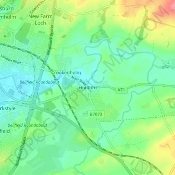
名称:Hurlford地形图、海拔、地势。
地点:Hurlford, East Ayrshire, Scotland, KA1 5BZ, United Kingdom (55.58134 -4.47391 55.62134 -4.43391)
平均海拔:49 米
最低海拔:22 米
最高海拔:111 米
其他地形图
点击地图以查看其地形、其海拔和其地势。

点击地图以显示海拔。
名称:Hurlford地形图、海拔、地势。
地点:Hurlford, East Ayrshire, Scotland, KA1 5BZ, United Kingdom (55.58134 -4.47391 55.62134 -4.43391)
平均海拔:49 米
最低海拔:22 米
最高海拔:111 米
点击地图以查看其地形、其海拔和其地势。