
Lantau Island地形图
点击地图以显示海拔。
关于这张地图
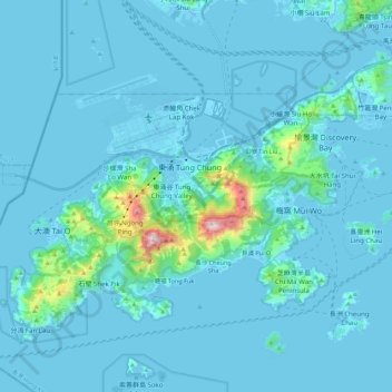
名称:Lantau Island地形图、海拔、地势。
平均海拔:55 米
最低海拔:-15 米
最高海拔:878 米
其他地形图
点击地图以查看其地形、其海拔和其地势。
Lantau Peak
China > Hong Kong > Islands District
Lantau Peak is located in central Lantau Island, with an elevation of 934 meters above sea level (23 metres shorter than Tai Mo Shan, Hong Kong's highest peak). Under the Köppen climate classification, Lantau Peak features a subtropical highland climate. Due to its elevation, strong winds and fog occur…
平均海拔:422 米