
Sawnee Mountain地形图
点击地图以显示海拔。
Sawnee Mountain
Sawnee Mountain is a low mountain between the piedmont and Appalachian foothills of the U.S. state of Georgia, north of Atlanta. Average rainfall/46.26in/yr/ average snowfall/5.7in/yr/. The name Sawnee Mountain actually refers to the entire ridge of approximately five miles (8 km) in length. At its summit, the elevation is 1,946 feet (593 m) above mean sea level, and is roughly 750 feet (230 m) above the surrounding terrain. The Sawnee Mountain range runs southwest to northeast, and consists of five knolls and three gaps (Chamblee, Sawnee, and Bettes). Located only a few miles north of Cumming, Georgia (the county seat), the mountain is the highest point in Forsyth county at 1,946 ft (593 m) above sea level. One of the highest peaks of metro Atlanta, it is taller than its more well-known neighbors Stone Mountain and Kennesaw Mountain by 260 ft (79 m) and 138 ft (42 m) respectively. Compared to other mountains in the area, however, Sawnee Mountain sits behind Bear Mountain and Pine Log Mountain, both in neighboring Cherokee County to the west.
关于这张地图
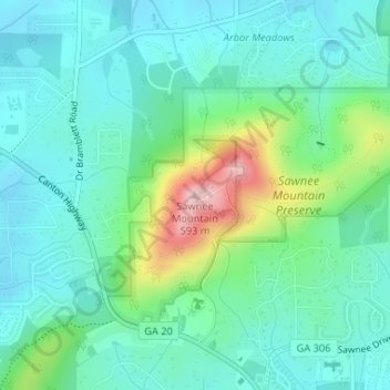
名称:Sawnee Mountain地形图、海拔、地势。
平均海拔:404 米
最低海拔:350 米
最高海拔:577 米
其他地形图
点击地图以查看其地形、其海拔和其地势。
Lake Lanier
United States > Georgia > Forsyth County > Cumming
According to the Army Corps of Engineers, the Dam has a current installed capacity of 126 megawatts and a hydraulic head of 136 feet. Other pertinent information on the reservoir, power plant, etc. can be found on the Mobile District Corps of Engineers web site.[12][13] Also, historic operational information…
平均海拔:351 米