
Airport Road地形图
点击地图以显示海拔。
关于这张地图
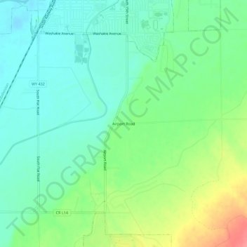
名称:Airport Road地形图、海拔、地势。
平均海拔:1,257 米
最低海拔:1,232 米
最高海拔:1,309 米
其他地形图
点击地图以查看其地形、其海拔和其地势。
Worland
United States > Wyoming > Washakie County
Due to the location within the Big Horn Basin, it is protected from severe weather by the surrounding mountains from nearly every direction. This topography results in weather that is highly continental with frigid and dry winters, little wind, little rainfall and few storms. Worland is the least windy…
平均海拔:1,268 米