London地形图
点击地图以显示海拔。
关于这张地图
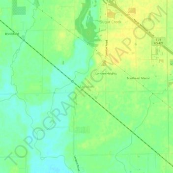
名称:London地形图、海拔、地势。
地点:London, Shelby County, Indiana, 46126, United States (39.60560 -85.94026 39.64560 -85.90026)
平均海拔:238 米
最低海拔:226 米
最高海拔:248 米
其他地形图
点击地图以查看其地形、其海拔和其地势。

点击地图以显示海拔。
名称:London地形图、海拔、地势。
地点:London, Shelby County, Indiana, 46126, United States (39.60560 -85.94026 39.64560 -85.90026)
平均海拔:238 米
最低海拔:226 米
最高海拔:248 米
点击地图以查看其地形、其海拔和其地势。