
Banga地形图
点击地图以显示海拔。
关于这张地图
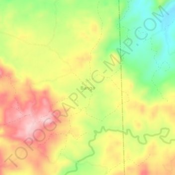
名称:Banga地形图、海拔、地势。
地点:Banga, Negros Occidental, Western Visayas, Philippines (9.76872 122.55719 9.80872 122.59719)
平均海拔:311 米
最低海拔:193 米
最高海拔:419 米
其他地形图
点击地图以查看其地形、其海拔和其地势。
Candoni
Philippines > Negros Occidental
Candoni is located 130 kilometres (81 mi) south-south-west of the provincial capital, Bacolod. It is approximately four hour drive from Bacolod City aboard a public utility vehicle and about two hours and 45 minutes on a private car. From Bacolod City, buses are available at Bacolod South Terminal. From…
平均海拔:308 米
Salvador Benedicto
Philippines > Negros Occidental
Although a small town, the town of Don Salvador Benedicto has seen a rise in its municipal economy thanks to tourism and local agriculture. Due to its high altitude like Baguio, the town can support crops that grow in temperate areas, making it ideal for a multitude of farming businesses. Tourism is on the…
平均海拔:708 米