
Mustang地形图
点击地图以显示海拔。
关于这张地图
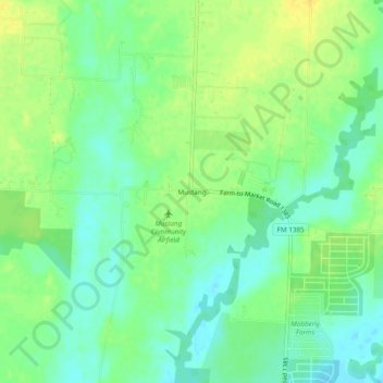
名称:Mustang地形图、海拔、地势。
地点:Mustang, Denton County, Texas, United States (33.30067 -96.92306 33.34067 -96.88306)
平均海拔:182 米
最低海拔:170 米
最高海拔:194 米
其他地形图
点击地图以查看其地形、其海拔和其地势。
Denton
United States > Texas > Denton County
Denton is on the northern edge of the Dallas–Fort Worth metropolitan area. These three cities form the area known as the "Golden Triangle of North Texas". According to the United States Census Bureau, the city has an area of 89.316 square miles (231.33 km2), of which 87.952 square miles (227.79 km2) is land…
平均海拔:195 米
Lewisville
United States > Texas > Denton County
Lewisville is at 33°2′18″N 97°0′22″W / 33.03833°N 97.00611°W / 33.03833; -97.00611 (33.038316, −97.006232) at an elevation of about 550 feet (170 m). It has a total area of 42.5 square miles (110 km2), of which 6.1 sq mi (16 km2) is covered by water. It lies at the southern end of Denton…
平均海拔:160 米
Little Elm
United States > Texas > Denton County
According to the U.S. Census Bureau, it has a total area of 18.6 square miles (48.3 km2), of which 14.6 square miles (37.7 km2) is land and 4.1 square miles (10.5 km2), or 21.83%, is covered by water. Little Elm has an average elevation of 545 feet above sea level.
平均海拔:171 米
Denton
United States > Texas > Denton County
Denton is located on the northern edge of the Dallas–Fort Worth metropolitan area. These three cities form the area known as the "Golden Triangle of North Texas." According to the United States Census Bureau, the city has a total area of 89.316 square miles (231.33 km2), of which 87.952 square miles (227.79…
平均海拔:195 米