
Singabangsa地形图
点击地图以显示海拔。
关于这张地图
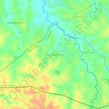
名称:Singabangsa地形图、海拔、地势。
地点:Singabangsa, Bogor, West Java, Java, 15370, Indonesia (-6.33477 106.44838 -6.29477 106.48838)
平均海拔:45 米
最低海拔:27 米
最高海拔:65 米
其他地形图
点击地图以查看其地形、其海拔和其地势。
Megamendung
Much of the district lies in an elevation of 500-600 metres, which moderates the temperature, and causing contrast to the heat of Greater Jakarta and other adjacent low-lying lands. Though much of the built-up area is not necessarily on rugged terrain, uneven ground is the most common terrain as it stands…
平均海拔:742 米