
Karachi地形图
点击地图以显示海拔。
Karachi
Karachi lies very close to a major fault line, where the Indian tectonic plate meets the Arabian tectonic plate. Within the city of Karachi are two small ranges: the Khasa Hills and Mulri Hills, which lie in the northwest and act as a barrier between North Nazimabad and Orangi. Karachi's hills are barren and are part of the larger Kirthar Range, and have a maximum elevation of 528 metres (1,732 feet).
关于这张地图
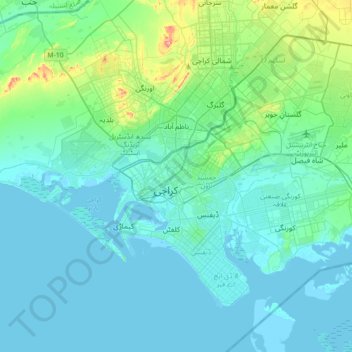
名称:Karachi地形图、海拔、地势。
平均海拔:20 米
最低海拔:-4 米
最高海拔:173 米