The Hague地形图
点击地图以显示海拔。
关于这张地图
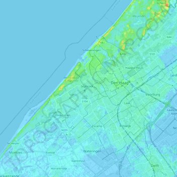
名称:The Hague地形图、海拔、地势。
地点:The Hague, South Holland, Netherlands (52.01485 4.18500 52.13504 4.42249)
平均海拔:2 米
最低海拔:-6 米
最高海拔:28 米
其他地形图
点击地图以查看其地形、其海拔和其地势。

点击地图以显示海拔。
名称:The Hague地形图、海拔、地势。
地点:The Hague, South Holland, Netherlands (52.01485 4.18500 52.13504 4.42249)
平均海拔:2 米
最低海拔:-6 米
最高海拔:28 米
点击地图以查看其地形、其海拔和其地势。