
Basingstoke地形图
点击地图以显示海拔。
Basingstoke
Situated in a valley through the Hampshire Downs at an average elevation of 88 metres (289 ft) Basingstoke is a major interchange between Reading, Newbury, Andover, Winchester, and Alton, and lies on the natural trade route between the southwest of England and London. The area had been something of an interchange even in ancient times. It had been cut by a Roman roadway that ran from northeast to southwest, from Silchester towards Salisbury (Sorbiodunum), and by another Roman road that linked Silchester (Calleva Atrebatum) in the north with Winchester (Venta Belgarum) to the south. These cross-cutting highways, along with the good agricultural land hereabouts, account for the many "Roman" villas in the area, mostly put up by Romanized native nobility (Roman villa). Even more ancient was the Harrow Way, a Neolithic trackway, possibly associated with the ancient tin trade, that crossed all of southern England from west to east, from Cornwall to Kent, passing right through Andover and Basingstoke.
关于这张地图
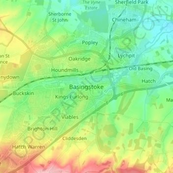
名称:Basingstoke地形图、海拔、地势。
平均海拔:107 米
最低海拔:59 米
最高海拔:206 米
其他地形图
点击地图以查看其地形、其海拔和其地势。
Basingstoke
United Kingdom > England > Hampshire > Basingstoke and Deane
Situated in a valley through the Hampshire Downs at an average elevation of 88 metres (289 ft) Basingstoke is a major interchange between Reading, Newbury, Andover, Winchester, and Alton, and lies on the natural trade route between the southwest of England and London. The area had been something of an…
平均海拔:110 米
Morgaston Wood
United Kingdom > England > Hampshire > Basingstoke and Deane > Sherborne St John
平均海拔:76 米
Monk Sherborne
United Kingdom > England > Hampshire > Basingstoke and Deane > Monk Sherborne
平均海拔:107 米
Baughurst
United Kingdom > England > Hampshire > Basingstoke and Deane > Wolverton Townsend
平均海拔:106 米