Corral del Risco地形图
点击地图以显示海拔。
关于这张地图
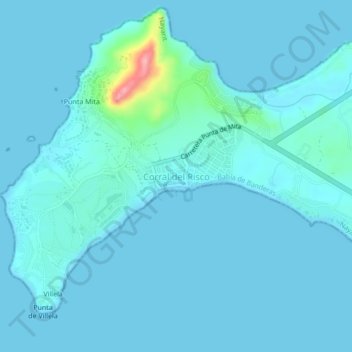
名称:Corral del Risco地形图、海拔、地势。
地点:Corral del Risco, Bahía de Banderas, Nayarit, México (20.75287 -105.53793 20.79287 -105.49793)
平均海拔:9 米
最低海拔:0 米
最高海拔:116 米
其他地形图
点击地图以查看其地形、其海拔和其地势。

点击地图以显示海拔。
名称:Corral del Risco地形图、海拔、地势。
地点:Corral del Risco, Bahía de Banderas, Nayarit, México (20.75287 -105.53793 20.79287 -105.49793)
平均海拔:9 米
最低海拔:0 米
最高海拔:116 米
点击地图以查看其地形、其海拔和其地势。