
Raichur地形图
点击地图以显示海拔。
关于这张地图
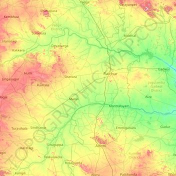
名称:Raichur地形图、海拔、地势。
地点:Raichur, Raichur District, Karnataka, India (15.38333 76.46667 16.78333 77.86667)
平均海拔:401 米
最低海拔:272 米
最高海拔:697 米
其他地形图
点击地图以查看其地形、其海拔和其地势。
Dakshina Kannada
The topography of the district is plain up to 30 km (18.64 mi) inside the coast and changes to undulating hilly terrain sharply towards the east in the Western Ghats. Teak, bamboo and rosewood trees are found in the hilly areas towards the east. The Geological Survey of India has identified this district as a…
平均海拔:109 米