
Calmsden地形图
点击地图以显示海拔。
关于这张地图
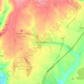
名称:Calmsden地形图、海拔、地势。
平均海拔:180 米
最低海拔:124 米
最高海拔:221 米
其他地形图
点击地图以查看其地形、其海拔和其地势。
Cirencester
United Kingdom > England > Gloucestershire > Cotswold District > Chesterton
On Cotswold Avenue is the site of a Roman amphitheatre which, while buried, retains its shape in the earthen topography of the small park setting. Cirencester was one of the most substantial cities of Roman-era Britain.
平均海拔:128 米
Cirencester
United Kingdom > England > Gloucestershire > Cotswold District
On Cotswold Avenue is the site of a Roman amphitheatre which, while buried, retains its shape in the earthen topography of the small park setting. Cirencester was one of the most substantial cities of Roman-era Britain.
平均海拔:128 米
Little Rissington
United Kingdom > England > Gloucestershire > Cotswold District > Little Rissington
平均海拔:171 米
Cirencester
United Kingdom > England > Gloucestershire > Cotswold District
On Cotswold Avenue is the site of a Roman amphitheatre which, while buried, retains its shape in the earthen topography of the small park setting. Cirencester was one of the most substantial cities of Roman-era Britain.
平均海拔:128 米
Upper Rissington
United Kingdom > England > Gloucestershire > Cotswold District > Upper Rissington
平均海拔:208 米
Great Rissington
United Kingdom > England > Gloucestershire > Cotswold District > Great Rissington
平均海拔:168 米
Cirencester Park
United Kingdom > England > Gloucestershire > Cotswold District > Sapperton
平均海拔:162 米
Botany Bay Wood
United Kingdom > England > Gloucestershire > Cotswold District > Stow-on-the-Wold
平均海拔:171 米
Cirencester
United Kingdom > England > Gloucestershire > Cotswold District > Chesterton
On Cotswold Avenue is the site of a Roman amphitheatre which, while buried, retains its shape in the earthen topography of the small park setting. Cirencester was one of the most substantial cities of Roman-era Britain.
平均海拔:128 米
Cirencester
United Kingdom > England > Gloucestershire > Cotswold District > Chesterton
On Cotswold Avenue is the site of a Roman amphitheatre which, while buried, retains its shape in the earthen topography of the small park setting. Cirencester was one of the most substantial cities of Roman-era Britain.
平均海拔:128 米
Bushley Muzzard, Brimpsfield
United Kingdom > England > Gloucestershire > Cotswold District > Nettleton > Watercombe
平均海拔:261 米
Bibury
United Kingdom > England > Gloucestershire > Cotswold District
The parish is approximately rectangular and stretches far to the rolling, elevated, north. It includes on outlying settlement, Ablington, in the upper valley. Bibury Farm is 300 metres (330 yd) from the village, 151 metres (495 ft) above Ordnance Datum (AOD), which is a similar elevation to much of the north.…
平均海拔:135 米
Knap House Quarry, Birdlip
United Kingdom > England > Gloucestershire > Cotswold District > Birdlip
平均海拔:222 米