
Kampung Palimbayan Indah地形图
点击地图以显示海拔。
关于这张地图
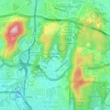
名称:Kampung Palimbayan Indah地形图、海拔、地势。
地点:Kampung Palimbayan Indah, Kuala Lumpur, 47820, Malaysia (3.14870 101.60660 3.18870 101.64660)
平均海拔:110 米
最低海拔:14 米
最高海拔:324 米
其他地形图
点击地图以查看其地形、其海拔和其地势。
KLCC Park
Malaysia > Kuala Lumpur > Kuala Lumpur
The park was designed to showcase a heritage of tropical greenery by integrating man's creation with nature. The park itself contrasts as a calm environment in the midst of the hustle and bustle of the city. The park features many combinations of man-made design such as cements, water features and also natural…
平均海拔:46 米