
North Cove地形图
点击地图以显示海拔。
关于这张地图
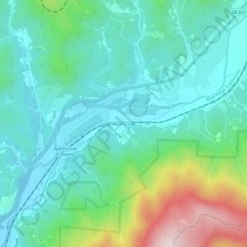
名称:North Cove地形图、海拔、地势。
地点:North Cove, McDowell County, North Carolina, United States (35.81596 -82.00900 35.85596 -81.96900)
平均海拔:564 米
最低海拔:430 米
最高海拔:978 米
其他地形图
点击地图以查看其地形、其海拔和其地势。
Marion
United States > North Carolina > McDowell County
With an elevation of 1,400 feet, Marion's climate is fairly warm during summer (which are typically longer than lower elevation areas in the United States that get the same average high and low temperatures in the summer), when temperatures tend to be in the 80s and 90s, and moderately cold during the winter,…
平均海拔:435 米