
Ivars地形图
点击地图以显示海拔。
关于这张地图
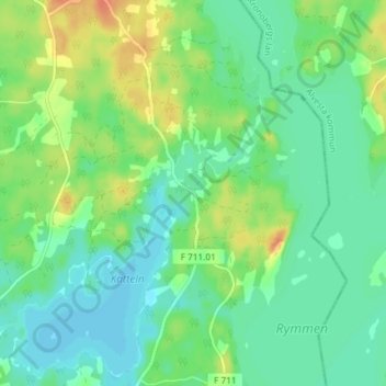
名称:Ivars地形图、海拔、地势。
地点:Ivars, Värnamo kommun, Sweden (57.06903 14.31322 57.10903 14.35322)
平均海拔:180 米
最低海拔:167 米
最高海拔:204 米
其他地形图
点击地图以查看其地形、其海拔和其地势。
Abisko National Park
Permafrost is common in the national park, though permafrost at lower elevations is disappearing because of global warming and increased snowfall.
平均海拔:740 米
Sarek
Sarek National Park is the most mountainous region in Sweden and it is the part of the country that mostly resembles an alpine countryside. Within the park are 19 summits higher than 1,900 m (6,200 ft), the most noted being the second highest summit in Sweden after the Kebnekaise – the Sarektjåkkå with a…
平均海拔:994 米
Ven
Along the entire coast, the island drops steeply towards the sea where the Öresund meets a rocky beach. This steep coast is called Backafall. Ven's backafall is a nature reserve established in 1990. There are no large forests, but smaller stands of trees occur closest to the coast the slightly higher…
平均海拔:13 米