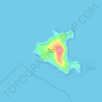
地理定位

Bedarra Island地形图

点击地图以显示海拔

关于这张地图

名称Bedarra Island地形图、海拔、地势。

地点Bedarra Island, Dunk, Cassowary Coast Regional, Queensland, Australia (-18.00975 146.14111 -17.99748 146.15469)

平均海拔:4 米

最低海拔:0 米

最高海拔:90 米

其他地形图

点击地图以查看其地形、其海拔和其地势

Brisbane

Australia > Queensland > Brisbane

平均海拔:45 米

Gold Coast

Australia > Queensland > Gold Coast

平均海拔:42 米

Port Stewart

Australia > Queensland

平均海拔:2 米

Mackay

Australia > Queensland

平均海拔:13 米

Gold Coast City

Australia > Queensland

平均海拔:87 米

Moreton Bay

Australia > Queensland

平均海拔:0 米

Townsville

Australia > Queensland

平均海拔:30 米

Brisbane

Australia > Queensland

平均海拔:87 米

Allenview

Australia > Queensland

平均海拔:68 米

Lyons

Australia > Queensland > Logan City

平均海拔:165 米

Hervey Bay

Australia > Queensland

平均海拔:6 米

Maleny

Australia > Queensland > Maleny

平均海拔:364 米

Scenic Rim Regional

Australia > Queensland

平均海拔:261 米

Goolman

Australia > Queensland > Ipswich City

平均海拔:118 米

Norwell

Australia > Queensland > Gold Coast City

平均海拔:5 米

Caloundra

Australia > Queensland > Sunshine Coast Regional

Caloundra, located on Queensland's Sunshine Coast, features a diverse coastal topography characterized by sandy beaches, rocky headlands, and nearby elevated terrains. The suburb of Kings Beach exemplifies this diversity, with its sandy shoreline to the south and southeast, and a rocky headland rising to about…

平均海拔:5 米

Toowoomba

Australia > Queensland

The city occupies the edge of the range and the low ridges behind it. Two valleys run north from the southern boundary, each arising from springs either side of Middle Ridge near Spring Street at an altitude of around 680 m. These waterways, East Creek and West Creek, flow together just north of the CBD to…

平均海拔:458 米

Rubyvale

Australia > Queensland

平均海拔:275 米

Noosa Heads

Australia > Queensland > Noosa Heads

平均海拔:9 米

Ipswich City

Australia > Queensland

平均海拔:84 米

Bundaberg

Australia > Queensland > Bundaberg Region

平均海拔:18 米

Cairns

Australia > Queensland

South of Smithfield and inland from the Northern Beaches along the edge of the Barron River flood plain are the suburbs of Caravonica, Kamerunga, Freshwater, and Stratford. This area is sometimes referred to as Freshwater Valley, though it is actually the lower part of Redlynch Valley; further up the valley…

平均海拔:176 米

Gladstone

Australia > Queensland

平均海拔:24 米

Rockhampton

Australia > Queensland

平均海拔:48 米

Russell Island

Australia > Queensland

平均海拔:8 米

Ipswich

Australia > Queensland > Ipswich

平均海拔:73 米

Gympie

Australia > Queensland > Gympie

平均海拔:124 米

Sunshine Coast

Australia > Queensland > Sunshine Coast Regional

The Sunshine Coast in Queensland, Australia, showcases a diverse topography that harmoniously blends coastal plains with rugged hinterlands. Along its eastern edge, the region features expansive sandy beaches and coastal dunes that transition smoothly into fertile lowlands. Inland, the terrain becomes more…

平均海拔:109 米

City of Brisbane

Australia > Queensland

Brisbane's topography is characterized by a series of hills and ranges that define its landscape. The city is situated on a low-lying floodplain, with the Brisbane River meandering through its heart, creating a winding course with many steep curves from the southwest to its mouth at Moreton Bay in the east.…

平均海拔:71 米

Herston

Australia > Queensland > City of Brisbane

平均海拔:23 米

Mount Cotton

Australia > Queensland

平均海拔:105 米

Mount Isa

Australia > Queensland

平均海拔:391 米

Darra

Australia > Queensland > City of Brisbane

平均海拔:33 米

Tamborine Mountain

Australia > Queensland

平均海拔:447 米

Bribie Island

Australia > Queensland

平均海拔:44 米

Daintree Rainforest

Australia > Queensland

平均海拔:59 米

Mount Gravatt

Australia > Queensland

平均海拔:70 米

Bundaberg Region

Australia > Queensland

平均海拔:70 米

Sunshine Coast Regional

Australia > Queensland

The Sunshine Coast Regional area in Queensland, Australia, features a diverse topography that ranges from coastal plains to rugged hinterlands. Along the coastline, the terrain is predominantly flat, with average elevations around 20 meters (66 feet) above sea level. Inland, the landscape transitions to…

平均海拔:56 米

Brisbane River

Australia > Queensland

The RAAF also perform a practice session in the days preceding the event, serving as an opportunity to both practice beforehand and also promote Riverfire. One of the most popular RAAF aircraft to perform at Riverfire was the F-111 which was known for performing a 'dump-and-burn' above the city. The final…

平均海拔:235 米

Cottonvale

Australia > Queensland > Cotton Vale

平均海拔:915 米

Redland Bay

Australia > Queensland > Redland City

平均海拔:17 米

Kenmore

Australia > Queensland > City of Brisbane

平均海拔:30 米

Mission Beach

Australia > Queensland

平均海拔:24 米

Innisfail

Australia > Queensland

平均海拔:12 米

Maryborough

Australia > Queensland > Maryborough

平均海拔:22 米

Redcliffe

Australia > Queensland

平均海拔:9 米

Gold Coast City

Australia > Queensland

平均海拔:87 米

Carruchan

Australia > Queensland

平均海拔:214 米

Moura

Australia > Queensland

平均海拔:120 米

Euleilah

Australia > Queensland

平均海拔:34 米

Pinkenba

Australia > Queensland > City of Brisbane

平均海拔:3 米

Stanthorpe

Australia > Queensland > Stanthorpe

Owing to its elevation, Stanthorpe features a subtropical highland climate. At an altitude of 811 metres (2,661 ft), Stanthorpe holds the record for the lowest temperature recorded in Queensland at −10.6 °C (12.9 °F) on 23 June 1961. Sleet and light snowfalls are occasionally recorded, with the most…

平均海拔:840 米

City of Brisbane

Australia > Queensland

Brisbane's topography is characterized by a series of hills and ranges that define its landscape. The city is situated on a low-lying floodplain, with the Brisbane River meandering through its heart, creating a winding course with many steep curves from the southwest to its mouth at Moreton Bay in the east.…

平均海拔:71 米

Bluff Rock

Australia > Queensland

平均海拔:25 米

Lake Samsonvale

Australia > Queensland

平均海拔:53 米

Bogie

Australia > Queensland

平均海拔:176 米

Wurdong Heights

Australia > Queensland

平均海拔:59 米

Gladstone

Australia > Queensland

平均海拔:24 米

Stanton Cross

Australia > Queensland > Ipswich City

平均海拔:28 米

Lamb Island

Australia > Queensland > Brisbane

The island is in the southern part of Moreton Bay between the Queensland mainland and North Stradbroke Island. It is within the Moreton Bay Marine Park. The elevation ranges from 0 to 26 metres (0 to 85 ft) above sea level. The land use on the island is predominantly residential.

平均海拔:4 米

Atherton

Australia > Queensland

平均海拔:822 米

Boreen Point

Australia > Queensland > Boreen Point

平均海拔:6 米

Beaudesert

Australia > Queensland

平均海拔:84 米

Charlestown

Australia > Queensland

平均海拔:369 米

Coral Sea

Australia > Queensland

平均海拔:81 米

Atherton

Australia > Queensland

平均海拔:808 米

Stanmore

Australia > Queensland

平均海拔:220 米

Moongan

Australia > Queensland

平均海拔:287 米

Macleay Island

Australia > Queensland

平均海拔:3 米

Memerambi

Australia > Queensland

平均海拔:455 米

Wowan

Australia > Queensland

平均海拔:119 米

Daintree Village

Australia > Queensland

平均海拔:51 米

Buaraba

Australia > Queensland

平均海拔:157 米

West Stowe

Australia > Queensland

平均海拔:47 米

Iveragh

Australia > Queensland

平均海拔:92 米

Tungamull

Australia > Queensland

平均海拔:50 米

Kaban

Australia > Queensland

平均海拔:960 米

Villeneuve

Australia > Queensland

平均海拔:133 米

Port Stewart

Australia > Queensland

平均海拔:2 米