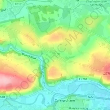
地理定位

Kerry Pike地形图

点击地图以显示海拔

关于这张地图

名称Kerry Pike地形图、海拔、地势。

地点Kerry Pike, St. Mary's, Cork, County Cork, Munster, T23 A406, Ireland (51.89150 -8.58776 51.93150 -8.54776)

平均海拔:55 米

最低海拔:2 米

最高海拔:157 米

其他地形图

点击地图以查看其地形、其海拔和其地势

Beaumont Park

Ireland > County Cork > Cork

平均海拔:12 米

Mayfield

Ireland > County Cork > Cork

平均海拔:73 米

Clashduff

Ireland > County Cork > Cork

平均海拔:21 米

Cork City

Ireland > County Cork > Cork

平均海拔:66 米

Gurranabraher A

Ireland > County Cork > Cork

平均海拔:56 米

Cork City

Ireland > County Cork > Cork

平均海拔:66 米

Lehenagh More

Ireland > County Cork > Cork

平均海拔:105 米

Sarsfieldscourt

Ireland > County Cork > Cork

平均海拔:83 米

Coolroe

Ireland > County Cork > Cork

平均海拔:38 米

Cork City

Ireland > County Cork > Cork

平均海拔:66 米

Rathcooney

Ireland > County Cork > Cork

平均海拔:91 米

Arderrow

Ireland > County Cork > Cork

平均海拔:95 米

Douglas

Ireland > County Cork > Cork

平均海拔:34 米

Maryborough

Ireland > County Cork > Cork

平均海拔:51 米

Ardamadane

Ireland > County Cork > Cork

平均海拔:92 米

Tramore Valley Park

Ireland > County Cork > Cork

平均海拔:28 米

Coolflugh

Ireland > County Cork > Cork

平均海拔:71 米

Shanakiel

Ireland > County Cork > Cork

平均海拔:67 米

Maglin

Ireland > County Cork > Cork

平均海拔:39 米

Atlantic Pond

Ireland > County Cork > Cork

平均海拔:38 米

Cork City

Ireland > County Cork > Cork

平均海拔:66 米

Grange

Ireland > County Cork > Cork

平均海拔:81 米

Currabeha

Ireland > County Cork > Cork

平均海拔:69 米

Blarney

Ireland > County Cork > Cork

平均海拔:58 米

Carhoo

Ireland > County Cork > Cork

平均海拔:81 米