
Lindis Pass地形图
点击地图以显示海拔。
Lindis Pass
Lindis Pass (Māori: Ōmakō) (elevation 971 m) is located in the South Island of New Zealand. A carpark at the top of the pass provides access to a viewpoint and two short trails to other viewing spots.
关于这张地图
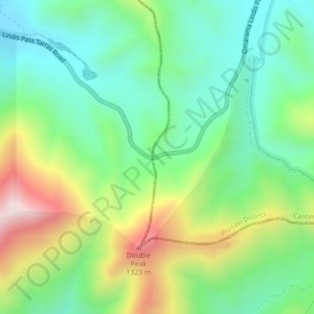
名称:Lindis Pass地形图、海拔、地势。
地点:Lindis Pass, Waitaki District, Canterbury, New Zealand (-44.58831 169.64303 -44.58821 169.64313)
平均海拔:1,011 米
最低海拔:806 米
最高海拔:1,407 米
其他地形图
点击地图以查看其地形、其海拔和其地势。
Lake Ōhau
New Zealand > Canterbury > Waitaki District
Wilding Pines (Pinus Cortorta, Pinus sylvestris) are problematic on the foreshore of Lake Ōhau. Pinus contorta grow “probably five to 10 times faster” in the Mackenzie Country (and Lake Ōhau) than in their native North America. They can establish themselves at altitudes of up to 2000 metres. Where they…
平均海拔:904 米