
Evenwood地形图
点击地图以显示海拔。
关于这张地图
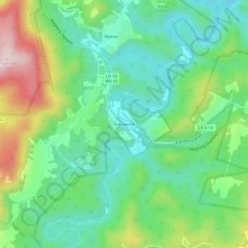
名称:Evenwood地形图、海拔、地势。
平均海拔:898 米
最低海拔:771 米
最高海拔:1,162 米
其他地形图
点击地图以查看其地形、其海拔和其地势。
Elkins
United States > West Virginia > Randolph County
Elkins is located at the confluence of the Tygart Valley River and Leading Creek. The average elevation is 2,000 feet (610 m) above sea level. According to the United States Census Bureau, the city has a total area of 3.43 square miles (8.88 km2), all land. Elkins is headquarters for the Monongahela National…
平均海拔:637 米
Spruce Knob Lake
United States > West Virginia > Randolph County
Spruce Knob Lake is a 23-acre (0.093 km2) reservoir located within the Monongahela National Forest in Randolph County, West Virginia, USA. The recreation area surrounding Spruce Knob Lake contains camping and picnicking facilities as well as a boating site. At an elevation of 3,840 feet, it is the highest lake…
平均海拔:1,204 米
Elkins
United States > West Virginia > Randolph County
Elkins is located at the confluence of the Tygart Valley River and Leading Creek. The average elevation is 2,000 feet (610 m) above sea level. According to the United States Census Bureau, the city has a total area of 3.43 square miles (8.88 km2), all land. Elkins is headquarters for the Monongahela National…
平均海拔:637 米