
Ramhurst地形图
点击地图以显示海拔。
关于这张地图
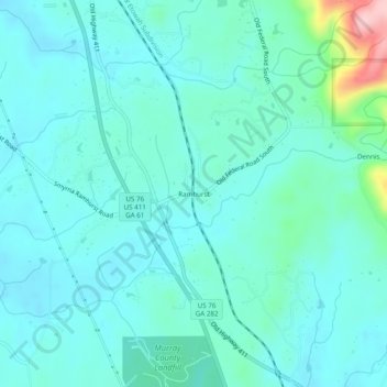
名称:Ramhurst地形图、海拔、地势。
地点:Ramhurst, Murray County, Georgia, United States (34.67814 -84.75077 34.71814 -84.71077)
平均海拔:245 米
最低海拔:212 米
最高海拔:423 米
其他地形图
点击地图以查看其地形、其海拔和其地势。
Chatsworth
United States > Georgia > Murray County
Chatsworth is located in central Murray County at 34°46′20″N 84°46′44″W / 34.77222°N 84.77889°W / 34.77222; -84.77889 (34.772336, -84.778977), in northwestern Georgia. It sits at an elevation of 750 feet (230 m) on the west side of the valley of Holly Creek, with 2,840-foot (870 m) Fort…
平均海拔:241 米