
Rocky Butte地形图
点击地图以显示海拔。
Rocky Butte
Rocky Butte lies in the northeast part of Portland within the city limits, in Multnomah County, part of the U. S. state of Oregon. It is one of the few smaller volcanic cones within or near Portland, along with Mount Tabor, Kelly Butte, and Powell Butte. According to the U.S. National Geodetic Survey, Rocky Butte has an elevation of 613 feet (187 m). It is surrounded on almost all sides by the Portland Delta.
关于这张地图
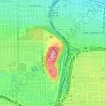
名称:Rocky Butte地形图、海拔、地势。
平均海拔:67 米
最低海拔:8 米
最高海拔:179 米
其他地形图
点击地图以查看其地形、其海拔和其地势。
Hoyt Arboretum
United States > Oregon > Multnomah County > Portland
Hoyt Arboretum is sited on steep slopes, straddling the SW Fairview Boulevard ridge above the Oregon Zoo and the Portland Japanese Garden. The elevation of the arboretum ranges from 650 feet to 900 feet, and there are several ravines within the arboretum. The hilly terrain of the arboretum was once in private…
平均海拔:209 米