
Rabun Gap地形图
点击地图以显示海拔。
关于这张地图
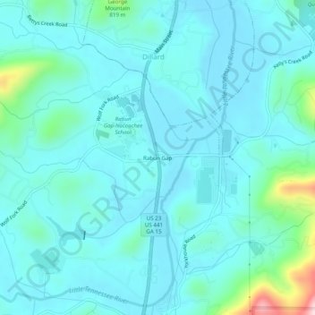
名称:Rabun Gap地形图、海拔、地势。
地点:Rabun Gap, Rabun County, Georgia, 30568, United States (34.93721 -83.40645 34.97721 -83.36645)
平均海拔:683 米
最低海拔:639 米
最高海拔:956 米
其他地形图
点击地图以查看其地形、其海拔和其地势。
Sky Valley
United States > Georgia > Rabun County
According to the United States Census Bureau, the city has a total area of 3.0 square miles (7.8 km2), all land. The elevation of the valley floor is approximately 3100 feet above sea level, while areas within the city limits on the slopes of Rabun Bald exceed 4200 feet. Sky Valley is Georgia's highest…
平均海拔:973 米
Tiger
United States > Georgia > Rabun County
Tiger lies in the extreme northeastern part of the state, just a few miles west of the Georgia-South Carolina border, and a few miles south of the Georgia-North Carolina border. The town's elevation is 1,962 feet (598 m), with several wooded hilltops reaching elevations of 2,100 to 2,200 feet. The town sits at…
平均海拔:608 米
Mountain City
United States > Georgia > Rabun County
Mountain City is an incorporated town in Rabun County, Georgia, United States. The population was 904 at the 2020 census. The town straddles the Eastern Continental Divide in a deep gap in the Blue Ridge Mountain front. The gap allows U.S. Route 441 to cross the range at an elevation of 2168 feet without the…
平均海拔:747 米
Tiger
United States > Georgia > Rabun County
Tiger lies in the extreme northeastern part of the state, just a few miles west of the Georgia-South Carolina border, and a few miles south of the Georgia-North Carolina border. The town's elevation is 1,962 feet (598 m), with several wooded hilltops reaching elevations of 2,100 to 2,200 feet. The town sits at…
平均海拔:608 米
Sky Valley
United States > Georgia > Rabun County
According to the United States Census Bureau, the city has a total area of 3.0 square miles (7.8 km2), all land. The elevation of the valley floor is approximately 3100 feet above sea level, while areas within the city limits on the slopes of Rabun Bald exceed 4200 feet. Sky Valley is Georgia's highest…
平均海拔:973 米