
Tornberget地形图
点击地图以显示海拔。
关于这张地图
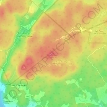
名称:Tornberget地形图、海拔、地势。
地点:Tornberget, Haninge kommun, Stockholm County, 137 93, Sweden (59.13693 18.01597 59.13703 18.01607)
平均海拔:77 米
最低海拔:36 米
最高海拔:103 米
其他地形图
点击地图以查看其地形、其海拔和其地势。
Ekerö kommun
Ekerö is the only municipality in the Lake Mälaren region composed exclusively of islands. Land elevation has reduced the number of islands and skerries to 140, the largest of which are Adelsö, Munsö, Ekerö, Färingsö, and Lovö. 2000 years ago, during the Roman Iron Age, Färingsön was more of an…
平均海拔:20 米
Södermalm
Sweden > Stockholm County > Stockholm
The name Södermalm (as Suthaermalm) is first mentioned in 1288 in a letter from Bishop Anund of Strängnäs. Until the early 17th century Södermalm was mainly a rural, agricultural area. Its first urban areas were planned and built in the mid 17th century, comprising a mixture of working class housing, such…
平均海拔:22 米