
Pilimathalawa地形图
点击地图以显示海拔。
关于这张地图
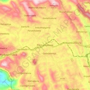
名称:Pilimathalawa地形图、海拔、地势。
平均海拔:543 米
最低海拔:230 米
最高海拔:757 米
其他地形图
点击地图以查看其地形、其海拔和其地势。
Horton Plains National Park
Horton Plains National Park (Sinhala: හෝර්ටන් තැන්න ජාතික උද්යානය, romanized: Hortan Thanna Jathika Udyanaya) is a national park in the central highlands of Sri Lanka that was designated in 1988. It is located at an elevation of 2,100–2,300 m (6,900–7,500…
平均海拔:2,010 米
Horton Plains National Park
Horton Plains National Park (Sinhala: හෝර්ටන් තැන්න ජාතික උද්යානය, romanized: Hortan Thanna Jathika Udyanaya) is a national park in the central highlands of Sri Lanka that was designated in 1988. It covers an area of 31km² and borders Thotupalakanda Nature…
平均海拔:2,010 米