
Catoctin Mountain地形图
点击地图以显示海拔。
Catoctin Mountain
Catoctin Mountain traverses Frederick County, Maryland and extends into northern Loudoun County, Virginia. It rises to its greatest elevation of 1,900 feet (580 m) above sea level just southwest of Cunningham Falls State Park and is transected by gaps at Braddock Heights (Fairview Pass), Point of Rocks on the Potomac River and Clarke's Gap west of Leesburg, as well as several other unnamed passes in Maryland and Virginia. The mountain is much lower in elevation in Virginia, reaching its highest peak just south of the Potomac at Furnace Mountain (891 feet/271 m) and with only one peak above 800 feet (240 m) south of Leesburg.
关于这张地图
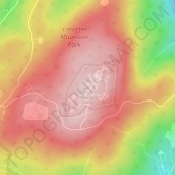
名称:Catoctin Mountain地形图、海拔、地势。
平均海拔:471 米
最低海拔:271 米
最高海拔:574 米
其他地形图
点击地图以查看其地形、其海拔和其地势。
Braddock Heights
United States > Maryland > Frederick County > Braddock Heights
Braddock Heights is located at an elevation of 950 feet (290 m) atop Braddock Mountain (as Catoctin Mountain is locally known) near the pass at Braddock Springs, so named after British General Edward Braddock and Lt. Colonel George Washington's use of the mountain pass on their way to Fort Duquesne during the…
平均海拔:179 米