
Columbia Plateau地形图
点击地图以显示海拔。
关于这张地图
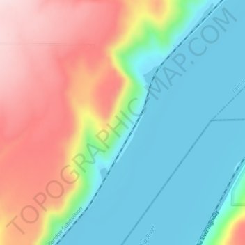
名称:Columbia Plateau地形图、海拔、地势。
地点:Columbia Plateau, Benton County, Washington, United States (45.99953 -119.00144 45.99963 -119.00134)
平均海拔:221 米
最低海拔:102 米
最高海拔:417 米
其他地形图
点击地图以查看其地形、其海拔和其地势。
Kennewick
United States > Washington > Benton County
Native Americans populated the area around modern-day Kennewick for millennia before being discovered and settled by European descendants. These inhabitants consisted of people from the Umatilla, Wanapum, Nez Perce, and Yakama tribes. Kennewick's low elevation helped to moderate winter temperatures. On top of…
平均海拔:157 米
Richland
United States > Washington > Benton County
According to the United States Census Bureau, the city has a total area of 39.11 square miles (101.29 km2), of which, 35.72 square miles (92.51 km2) is land and 3.39 square miles (8.78 km2) is water. Elevation at the airport is 120 m (390 ft).
平均海拔:164 米
Kennewick
United States > Washington > Benton County
Native Americans populated the area around modern-day Kennewick for millennia before being discovered and settled by European descendants. These inhabitants consisted of people from the Umatilla, Wanapum, Nez Perce, and Yakama tribes. Kennewick's low elevation helped to moderate winter temperatures. On top of…
平均海拔:157 米
West Richland
United States > Washington > Benton County
The original people of the region were the Chemnapum Indians (closely related to the Wanapum tribe), living near the mouth of the Yakima River. Lewis and Clark passed through the area in 1805, and an expedition of the Army Corps of Topographical Engineers headed by Robert E Johnson mapped the Yakima Valley in…
平均海拔:146 米
Richland
United States > Washington > Benton County
According to the United States Census Bureau, the city has a total area of 39.11 square miles (101.29 km2), of which, 35.72 square miles (92.51 km2) is land and 3.39 square miles (8.78 km2) is water. Elevation at the airport is 120 m (390 ft).
平均海拔:164 米
West Richland
United States > Washington > Benton County
The original people of the region were the Chemnapum Indians (closely related to the Wanapum tribe), living near the mouth of the Yakima River. Lewis and Clark passed through the area in 1805, and an expedition of the Army Corps of Topographical Engineers headed by Robert E Johnson mapped the Yakima Valley in…
平均海拔:146 米
Kennewick
United States > Washington > Benton County
Native Americans populated the area around modern-day Kennewick for millennia before being discovered and settled by European descendants. These inhabitants consisted of people from the Umatilla, Wanapum, Nez Perce, and Yakama tribes. Kennewick's low elevation helped to moderate winter temperatures. On top of…
平均海拔:157 米