
High Roding地形图
点击地图以显示海拔。
关于这张地图
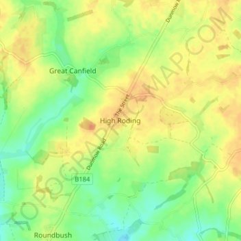
名称:High Roding地形图、海拔、地势。
地点:High Roding, Uttlesford, Essex, England, CM6 1YH, United Kingdom (51.81016 0.30609 51.85016 0.34609)
平均海拔:79 米
最低海拔:61 米
最高海拔:93 米
其他地形图
点击地图以查看其地形、其海拔和其地势。
Little Easton
United Kingdom > England > Essex > Uttlesford > Little Easton
Living in the parish were Lord and Lady Brooke, the later Earl and Countess of Warwick, at Easton Lodge, who were also resident at Berwick House in the Stable Yard of St James's Palace, London, and in 1902, after elevation to title, Warwick Castle. Parish occupations in 1882 included three farmers, one of whom…
平均海拔:88 米