
Molamenqing地形图
点击地图以显示海拔。
Molamenqing
Molamenqing, also known as Phola Gangchen, is an eastern outlier of Shishapangma, the 14th-highest peak in the world. Both are in the Jugal Himal, a subrange of the Himalaya in Tibet. (This range is contiguous with, and often considered a part of, the Langtang Himal.) Its elevation is also given as 7,661 m (25,135 ft); the elevation given here is from a Chinese survey. Molamenqing is little-known, partly since it does not have much independent stature. Its topographic prominence, i.e. its rise above the saddle connecting it with Shishapangma, is only 430 metres, which is relatively small for a Himalayan peak, although large enough for it to qualify in some reckonings as an independent peak.
关于这张地图
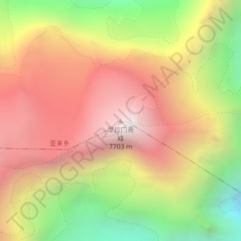
名称:Molamenqing地形图、海拔、地势。
平均海拔:6,756 米
最低海拔:5,658 米
最高海拔:7,655 米